Transit - Subway & Bus Times
- 4.6
- Rating
- 10.00M
- Installs
- Free
- Price

 Analysis by App-foxy
When I need to cross a city without driving, I usually begin with a simple question: which combination of train, subway, bus, or walking will get me there with the least uncertainty? Transit - Subway & Bus Times is built for that exact moment. It is a free Maps & Navigation app from Transit, Inc., and I found its main appeal in turning a messy public-transport trip into a sequence I can actually follow.
The app is aimed at people using systems such as MTA, NJ Transit, MBTA, SEPTA, BART, MARTA, CTA, and many other networks. Its reach is one reason it has become so widely used: it has passed 10 million installs, with a 4.6 average from roughly 337 thousand ratings. Those figures suggest a mature product, but they do not remove the need to test whether its way of planning suits your own city and travel habits.
From a vague trip to a plan I can follow
When a trip is still vague, I find it useful to start by naming the destination and then judging the journey as a whole, rather than choosing a line too early. That gives me room to weigh walking, transfers, and how easy the route will be to recognize on the ground. Next, I’ll look at what makes that plan practical when the city gets busy and the timing matters.
You May Also Like

 Blood Strike: 2.5 Anniversary
Blood Strike’s Loadouts Turn Every Drop Into a Tactical Gamble
A close look at Blood Strike’s custom loadouts: how fast access to signature weapons reshapes its battle royale rhythm, rewards preparation, and narrows the gap between fights.

 Pandora - Music & Podcasts
Pandora’s Music Is Easy to Start, but Harder to Recover
Pandora’s strength is its low-effort path from a seed to a station. Its weak spot is how much confidence it asks you to place in connection, setup, and quiet recovery.

 8 Ball Pool
 Is Built on Rivalries, Rematches, and Routine
A close look at the rivalries, rematches, shared routines, and unanswered safety questions that turn a quick pool match into a persistent mobile community.

 Samsung Music
’s Quiet Strength Is Playing What You Already Own
Its reach comes less from spectacle than from dependable access to a personal library. That simplicity is both the app’s strongest retention engine and its ceiling.

 AccuWeather: Weather Radar
AccuWeather Review: A Quick, Clear Forecast for Everyday Decisions
For everyday plans, the best forecast is the one you can understand quickly. AccuWeather makes rain timing, radar, and local conditions easy to act on, with a few trade-offs.

 Hill Climb Racing
Why Hill Climb Racing Still Turns Crashes Into One More Run
A tiny car, a bumpy hill and one more upgrade: Hill Climb Racing keeps resurfacing because its simple chaos makes every near-miss feel personal.
More From Our News Desk
View All News


Starting with the real travel problem
My useful starting point is not a station name. It is the actual destination: a café, office, museum, appointment, or friend’s home. That matters because a public-transport journey rarely ends at the platform. I still need to walk from my current position to a stop, change vehicles when necessary, and walk again after getting off. Transit makes more sense when used as a door-to-door planning tool rather than as a timetable viewer.
For a typical weekday trip, I would open the app, enter where I am going, and check the available routes. The practical question is not always which option is fastest. A route with one fewer transfer may be preferable when I am carrying luggage, travelling with a child, or arriving somewhere at a fixed time. I use the alternatives to compare speed, walking, and the number of handoffs instead of accepting the first result automatically.
This is one of the app’s strongest qualities: it encourages a decision based on the whole journey. A conventional map app may be excellent for driving or walking, while a transport operator’s own app may be authoritative for one network. Transit is more useful when I need to compare several public options in one place, especially when a trip crosses the boundary between different services.
Reading the route before leaving
Once a route appears, I pay attention to the order of events. I want to know which stop comes first, which line or vehicle I need, where the transfer happens, and how much walking surrounds the ride. This preview is valuable because public-transport mistakes usually happen at transitions, not while sitting on a vehicle. Missing the correct platform or leaving at the wrong stop can undo an otherwise perfect itinerary.
A useful habit is to inspect at least one alternative before starting. The quickest option can depend on a tight connection, while a slightly slower route may be easier to recognize and less stressful. I also check the final walking segment. A route that looks efficient on paper may finish on a busy road, at a large station, or on the wrong side of a destination. That last stretch can change the best choice.
The app’s store summary highlights coverage across major systems and more than a thousand cities. In practice, that broad scope is most helpful for travellers who do not want to learn a new transport application every time they visit another place. It also makes the app useful for people who live near a regional border and regularly combine services rather than staying within one operator’s network.
Following the trip instead of memorizing it
After choosing a route, I treat the app as a travel companion rather than a one-time search box. The important workflow is input, selection, movement, transfer, and arrival. I start with the destination, select a route that matches my priorities, and then keep the journey details available while I move through the city. That reduces the need to remember every station or stop name.
For example, imagine leaving work during a busy evening and heading to a restaurant in an unfamiliar neighborhood. I would first compare the route with the fewest changes against the route with the shortest estimated travel time. Before boarding, I would confirm the direction of travel and the first stop. During the ride, I would prepare for the transfer rather than waiting until the last moment. After changing, I would check the final stop and walking approach before leaving the vehicle.
That sounds ordinary, but it is where a dedicated transit app earns its place. The value is not just showing a line on a map. It is keeping the stages connected so I can move from one decision to the next without rebuilding the trip manually in separate tools.
The handoffs are where the app helps most
Every public-transport journey contains handoffs: from phone to station entrance, from one line to another, from vehicle to sidewalk, and sometimes from one operator’s service to a different one. Transit is particularly useful at the planning stage because it puts these pieces into one journey view. I can see whether a transfer is central to the route rather than discovering it only after boarding.
I also find the handoff between planning and real-world observation important. The screen can tell me which service to seek, but I still need to read signs, watch platform displays, and notice whether the vehicle heading toward me is travelling in the right direction. I never treat an app route as permission to stop paying attention. Instead, I use it to narrow the number of things I must verify around me.
For a visitor, this can be more reassuring than relying on a local operator application alone. A local app may offer deeper information for its own network, but it may not be as convenient when the journey involves another service. Transit’s advantage is the neutral overview. Its trade-off is that the overview may not replace the operator’s own notices or station information when a disruption is developing.
What I do when plans change
Public transport is not a controlled environment. A departure can be delayed, a platform can change, or I can simply miss the vehicle while buying a ticket or crossing a large station. When that happens, I return to the route alternatives rather than clinging to the original plan. The best recovery may be another departure on the same line, a different transfer, or a short walk to another stop.
This is also where I recommend leaving a little personal margin. A route that works only if every connection is immediate is fragile, even if it looks attractive in the app. I prefer a plan that gives me a recognizable transfer and a reasonable walking segment when the appointment matters. Transit helps me compare those choices, but it cannot remove the uncertainty built into city travel.
One less obvious benefit is that the app changes how I think about missed connections. Instead of seeing a failed transfer as the end of the trip, I treat it as a new starting condition. I check the next practical route, consider whether walking to another stop is sensible, and continue from there. That mindset is more useful than repeatedly refreshing one timetable.
The result at the destination
A successful result is not merely arriving quickly. It is arriving with enough confidence that I know why I am getting off, which direction to walk, and whether I have completed the final part of the route. Transit is strongest when it reduces that mental load. I can focus on the appointment, the person I am meeting, or the city around me instead of constantly calculating the next move.
For regular commuters, the app can become a quick daily checkpoint. For occasional riders, it works as a translator between an unfamiliar transit map and a real destination. For visitors, the broad city coverage is especially attractive because the same general workflow follows them from one network to another. I would recommend it first to anyone who uses buses, subways, or trains often enough to value route comparisons but does not want to master every operator’s terminology.
The app is also suitable for families and groups, although I would make the final choice with the group’s limitations in mind. The route with the shortest walking section may be better than the fastest one when someone has reduced mobility or when a stroller is involved. A result that looks efficient for one person may be awkward for four people, so I use the app to expose the options and then apply human judgment.
Where the workflow breaks
The first limitation is that coverage does not automatically mean equal usefulness in every city. Transit, Inc. supports a very broad range of locations, but the quality of a journey depends on the local network, available service information, and how clearly the city’s routes can be represented. I would test it before relying on it for an important first-day arrival, particularly if the trip involves rural service or an unusual regional operator.
The second limitation is the difference between planning information and what is happening physically on the street. An app can guide me toward a stop, but construction, crowding, temporary entrances, and confusing station layouts still require attention. For a major disruption, I would compare Transit’s guidance with signs and announcements from the transport authority. The dedicated operator app may be the better second source when I need a network-specific alert or a highly local explanation.
There can also be friction when a route contains several transfers. The more handoffs a trip has, the more opportunities there are for a small timing difference to matter. I do not choose a complicated route just because it saves a few minutes. This is a key trade-off: Transit makes complex combinations visible, but visibility does not make a complex trip simple.
Another point to consider is cost. The app itself is free, while in-app purchases are listed from $2.99 to $50.00 per item. I would begin with the free experience and decide whether any optional purchase fits my needs before spending money. Anyone seeking a completely purchase-free setup should pay attention to what the app presents during use, especially if they only need occasional route planning.
Privacy-conscious users may also prefer to be deliberate about how they enter locations. I use a specific destination when I need a route and avoid leaving unnecessary searches open. That is not a criticism unique to this app; it is simply sensible behavior for any navigation tool that works with places and journeys. People who want no digital assistance at all, or who prefer printed maps and station staff, may find the app unnecessary.
How it compares with familiar alternatives
Compared with a general-purpose map application, Transit feels more focused on the sequence of public-transport decisions. A general map is often better when I am combining driving, cycling, and walking, or when I want a broad place-search experience. Transit is the more natural choice when the central question is which bus, subway, or train to take and how to change between them.
Compared with an individual transport authority’s application, Transit is more convenient for multi-network journeys and travel across cities. The authority’s own tool may be preferable for highly specific local notices, official service messages, or details tied to one system. I see the two types of app as complementary rather than mutually exclusive: Transit for the complete route, the operator’s channel for local confirmation when conditions are changing.
Compared with checking a timetable manually, the app saves effort by connecting departure, transfer, and arrival into one plan. Manual checking can still be useful as a backup, particularly when a station has poor connectivity or when I want to verify a single departure. The practical advantage of Transit is not that it makes every journey perfect; it is that it gives me a clearer starting plan and more reasonable alternatives when the first plan fails.
Who should install it
I think this app is a strong fit for city residents who regularly mix buses and rail, visitors moving through unfamiliar networks, and commuters who want to compare a fast route with a simpler one. It is also useful for anyone who has previously missed a connection because they focused only on the first vehicle and forgot the transfer or final walk.
I would be more cautious recommending it to someone who drives almost everywhere, needs detailed cycling navigation, or travels mainly through a transport system with unusual service patterns. Those users may get more value from a different navigation tool or the local operator’s own application. Likewise, if you need guaranteed accessibility details for every station or a definitive response during a serious disruption, I would not rely on one route planner alone.
For most public-transport users, however, the balance is convincing. The app has been available since July 29, 2013, and its current version is 6.0.13, which places it among the established tools in this space. It is rated for Everyone and supports devices running Android 7.0 or later, making the basic audience broad rather than limited to recent phones.
My recommendation after using the full workflow
My honest view is that Transit works best when I use it as a decision aid, not as an unquestionable authority. I enter the destination, compare routes, study the transfers, choose a plan that matches the people and timing involved, and keep checking the physical signs around me. That workflow turns the app’s broad network coverage into something practical.
The most useful habit is to inspect the handoffs before leaving, not after the first vehicle arrives. That one step reveals whether the route is genuinely comfortable, whether the final walk is realistic, and whether a slower alternative would be wiser. It also makes recovery easier if a connection is missed.
Transit, Inc. has made a free app that addresses a very specific everyday problem: moving through public transport without stitching together several unrelated searches. It has limitations around local conditions, complicated transfers, and the need for human verification, but those are manageable when I understand what the app can and cannot do. If buses, subways, and trains are part of your normal travel, I would recommend giving it a try; if they are not, a general map may be all you need.
FAQs for Transit - Subway & Bus Times
01What features does the Transit app offer for commuters?
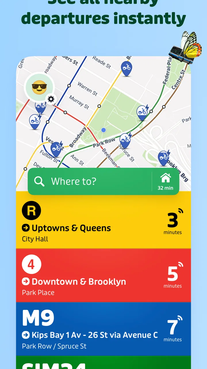
The Transit app provides real-time tracking for buses and subways, ensuring you know exactly when your ride will arrive. It offers step-by-step navigation, trip planning, and service disruption alerts. Plus, it includes bike-share information and car-sharing options, making it a one-stop solution for urban commuting.
02Is the Transit app available in my city?
Transit is supported in many major cities worldwide, covering most metropolitan areas. However, availability can vary, and it's recommended to check the app's official website or app store listing for a complete list of supported locations to ensure your city is covered.
03How accurate are the real-time updates in the Transit app?
The Transit app leverages data from local transit agencies and user inputs, which generally provides accurate real-time updates. However, accuracy can sometimes be influenced by network issues or delays from the transit agency itself. Most users find it reliable for everyday use.
04Does the Transit app require an internet connection to function?
While the Transit app offers some offline functionality, such as viewing schedules, an internet connection is necessary for real-time updates and accurate navigation. For the best experience, ensure your device is connected to the internet when using the app for live tracking and alerts.
05Is the Transit app free to use, or does it require a subscription?
The Transit app is free to download and use, offering most of its core features without charge. However, it also offers a premium subscription called 'Transit Royale' that includes additional features like customizable themes and enhanced real-time updates for a small monthly or annual fee.
Pros
- Real-time updates improve journey planning.
- User-friendly interface for easy navigation.
- Covers multiple transit modes in one app.
- Offline schedules available for convenience.
- Personalized alerts for favorite routes.
Cons
- In-app ads can be distracting at times.
- Occasional lag in real-time data updates.
- Limited features in free version.
- Battery drain with prolonged use.
- Complex settings for beginners.

Transit - Subway & Bus Times
Gallery